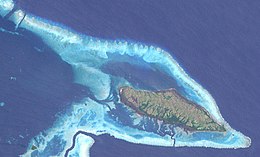
Yeina Island
Nickname: Piron Island | |
|---|---|
 Yeina island. Meiwa island is in the right corner. | |
| Geography | |
| Location | Oceania |
| Coordinates | 11°19′48″S 153°26′30″E / 11.33000°S 153.44167°E[1] |
| Archipelago | Louisiade Archipelago |
| Adjacent to | Solomon Sea |
| Total islands | 1 |
| Major islands |
|
| Area | 16 km2 (6.2 sq mi) |
| Length | 9.5 km (5.9 mi) |
| Width | 3.2 km (1.99 mi) |
| Highest elevation | 80 m (260 ft) |
| Highest point | Mount Yeina |
| Administration | |
| Province | |
| District | Samarai-Murua District |
| LLG[2] | Yaleyamba Rural Local Level Government Area |
| Island Group | Yeina Group |
| Largest settlement | Buwo (pop. ~250) |
| Demographics | |
| Population | 437 (2014) |
| Pop. density | 27.3/km2 (70.7/sq mi) |
| Ethnic groups | Papauans, Austronesians, Melanesians. |
| Additional information | |
| Time zone | |
| ISO code | PG-MBA |
| Official website | www |
Yeina Island is an island of volcanic origin in the Southeast Louisiade Archipelago in Milne Bay Province, Papua New Guinea.
Geography[edit]
The island has an area of 16 km2. The island is hilly, rising to 80 m at Mt. Yeina. The island is 10 km north of Vanatinai, and separated from it with the Yuma Channel. It is also 10 km east of Pana Tinani. The island is circled by a coral reef. The interior of the island is dominated by a chain of low, grassy hill, surrounded by a coastal forest, with many mangrove areas. Between Yeina and Vanatinai is the Marx Reef.
History[edit]
The island was discovered in the late 18th century.
Population[edit]
At the census of population in 2014, the island had 437 inhabitants, spread across 4 villages. The main town is Buwo, on the West coast. Former town of Kabagi-bagi was damaged by hurricanes recently. Nearly entire island population have moved to the village of Buwo.
References[edit]

