
Springdale, Brampton
Springdale | |
|---|---|
Suburban district | |
 Aerial view of Springdale | |
| Country | Canada |
| Province | Ontario |
| Regional municipality | Peel |
| City | Brampton |
| Government | |
| • MPs | Ruby Sahota (Brampton North) Maninder Sidhu (Brampton East) |
| • MPPs | Graham McGregor (Brampton North) Hardeep Grewal (Brampton East) |
| • Councillors | Gurpartap Singh Toor (Regional councillor) (Wards 9 & 10) Harkirat Singh (City councillor) (Wards 9 & 10) |
| Population | |
| • Total | 89,524 |
| Forward sortation area | |
Springdale is a large suburban district in Brampton, Ontario, Canada covering 4,000 acres (1,600 ha)[2] in the northern part of the city. It is generally bounded by Countryside Drive to the north, Bovaird Drive to the south, Heart Lake Road to the west, and Airport Road to the east.[3] Springdale is sometimes jocularly referred to as Singhdale due to its large population of Sikh Canadians, who make up 39.6% of the community's population and often have the last name Singh.[4]
History[edit]

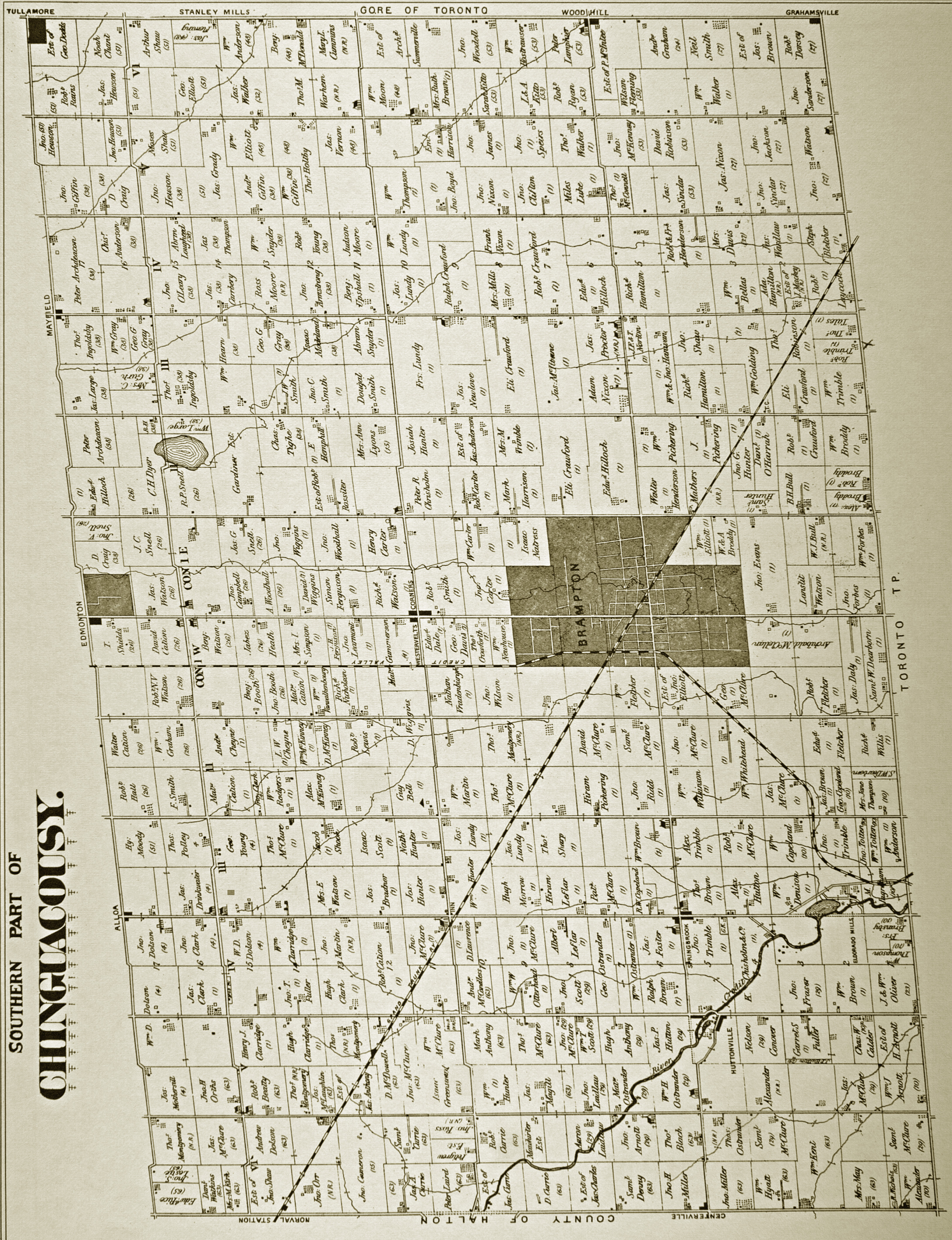
The present-day area of Springdale was located in the southeastern part of Chinguacousy Township before the township was amalgamated into the city of Brampton in 1974.
Located at the east end of present-day Springdale along Airport Road was the hamlet of Stanley’s Mills;[5] established in 1820. By 1860, the hamlet, characterized by an important milling industry, consisted of "three mills, a wagon shop, a blacksmith, tailor, seamstress, inn, store, post office, and Methodist church."[6] The sole remaining vestige of the hamlet is the designated heritage site at 10416 Airport Road, a Gothic revival brick residence built circa 1860 and associated with the Alderson family, among Brampton’s earliest settlers.[7] The Aldersons operated a mill in the 1860s and 1870s on the creek to the south of the present house.[7]
Two other designated heritage sites are along Torbram Road and reflect the area’s rural and agricultural past. The Elliott Farmhouse, of a vernacular Ontario Gothic style, was built about 1865.[8] The Elliott Homestead, of a Gothic Revival style, was built in 1876 and is linked to the former Harrison Methodist Church a kilometre south.[9]
Springdale was planned in the 1980s, and construction began in 1991.[10] The $5 billion “town within a city” was expected to be completed around 2005, and would house 75,000 people in 22,000 homes on a 4,000-acre site.[11] The project was planned to include "a hospital, 17 churches [and places of worship], 13 public and nine separate schools, a public library, two fire stations, a police station, a public transit terminal, 45 community parks, a large regional shopping centre, 18 plazas, and three low-rise office complexes,"[12] as well as over 700 acres of park space or open green space and 120 kilometres of paved bike paths.[13] As part of the "green" focus for Springdale, developers also gave the community’s eight different neighbourhoods a distinct geographical theme, such as mountains, tundra, grasslands, forests, deserts, and so on, and named the streets to reflect that particular environment.[14]
In 2007, Highway 410 was extended from it original northern terminus at Bovaird Drive to Mayfield Road through the west end of Springdale,[15] with an interchange at Sandalwood Parkway.
Politics[edit]
Springdale is split in federal and provincial representation between Brampton North[16] and Brampton East.[17] Brampton North covers the area west of Torbram Road, south of Sandalwood Parkway, west of Bramalea Road, and north of Sandalwood Parkway. Brampton East covers the area east to Airport Road.
Infrastructure[edit]

Brampton Civic Hospital, opened in 2007, is located in the area, along with two fire stations and a paramedic station.
Trinity Common Mall is a large shopping plaza in the area and includes a Cineplex movie theatre and transit terminal.
Recreation[edit]
The Save Max Sports Centre, formerly Brampton Soccer Centre, opened in 2007.
The Springdale branch of the Brampton Library opened in 2018.
Demographics[edit]
According to the 2016 Census, the top six mother tongues in the L6R forward sortation area (which is largely the area of Springdale) are English (36.3%), Punjabi (34.4%), Gujarati (3.6%), Urdu (2.8%), Tamil (2.6%), and Hindi (2.5%).[19]
Immigrants make up 59.7% of residents in the area, compared to 52.3% for the city. Among the immigrant population, the top six places of birth are India (55.8%), Jamaica (6.6%), Guyana (4.9%), Pakistan (4.3%), Sri Lanka (4.3%), and the Philippines (3%).[20]
| Immigrant source countries (2016) | |||||||||||||||||||||||
| Country | % | ||||||||||||||||||||||
|---|---|---|---|---|---|---|---|---|---|---|---|---|---|---|---|---|---|---|---|---|---|---|---|
| 55.8 | |||||||||||||||||||||||
| 6.6 | |||||||||||||||||||||||
| 4.9 | |||||||||||||||||||||||
| 4.3 | |||||||||||||||||||||||
| 4.3 | |||||||||||||||||||||||
| 3 | |||||||||||||||||||||||
| 1.9 | |||||||||||||||||||||||
| 1.5 | |||||||||||||||||||||||
| 1.3 | |||||||||||||||||||||||
| 1.1 | |||||||||||||||||||||||
| 1.1 | |||||||||||||||||||||||
| 0.9 | |||||||||||||||||||||||
| 0.8 | |||||||||||||||||||||||
| 0.6 | |||||||||||||||||||||||
| 0.6 | |||||||||||||||||||||||
| |||||||||||||||||||||||
| Mother tongue | % |
|---|---|
| English | 36.3 |
| Punjabi | 34.4 |
| Gujarati | 3.6 |
| Urdu | 2.8 |
| Tamil | 2.6 |
| Hindi | 2.5 |
| Spanish | 1.4 |
| Tagalog (Filipino) | 1.3 |
| Italian | 1.1 |
| Vietnamese | 0.7 |
| Akan (Twi) | 0.7 |
| Cantonese | 0.6 |
| Portuguese | 0.5 |
| Malayalam | 0.5 |
| Persian (Farsi) | 0.5 |
| French | 0.4 |
| Arabic | 0.4 |
| Knowledge of language | % |
|---|---|
| English | 92.3 |
| Punjabi | 42.8 |
| Hindi | 14.6 |
| French | 4.7 |
| Urdu | 4.5 |
| Gujarati | 4.2 |
| Tamil | 3.4 |
| Spanish | 1.9 |
| Tagalog (Filipino) | 1.7 |
| Italian | 1.4 |
| Akan (Twi) | 1 |
| Vietnamese | 0.9 |
| Cantonese | 0.9 |
| Portuguese | 0.9 |
| Persian (Farsi) | 0.7 |
| Arabic | 0.7 |
| Malayalam | 0.7 |
Education[edit]
There are numerous elementary and middle schools, and four secondary schools in the area.
Peel District School Board[edit]
Elementary and middle schools
- Carberry Public School
- Eagle Plains Public School
- Fernforest Public School
- Great Lakes Public School
- Hewson Public School
- Larkspur Public School
- Lougheed Middle School
- Mountain Ash Public School
- Robert J. Lee Public School
- Shaw Public School
- Springdale Public School
- Stanley Mills Public School
- Sunny View Middle School
Secondary schools
Dufferin-Peel Catholic District School Board[edit]
- Blessed Michael J. McGivney Catholic School
- Father Clair Tipping School
- Good Shepherd Elementary School
- Our Lady of Providence School
- St. Isaac Jogues Elementary School
- St. Marguerite d'Youville Secondary School
Notable people[edit]
- Ayo Akinola - professional soccer player
- Anthony Bennett - professional basketball player
- Nakas Onyeka - professional Canadian football player
- Tristan Thompson - professional basketball player
References[edit]
- ^ "2021 Census of Population". www12.statcan.gc.ca. Statistics Canada. 15 January 2001.
- ^ Sewell, John (1993). The shape of the city: Toronto struggles with modern planning. University of Toronto Press. p. 238. ISBN 978-0-8020-7409-6.
- ^ "Springdale Secondary Plan Area 2" (PDF). City of Brampton. October 2019. p. 3.
- ^ "How Brampton, a town in Ontario, was dubbed a ghetto". The Globe and Mail. 3 June 2016.
- ^ "Township of Chinguacousy (southern part) map". The Canadian County Atlas Digital Project. McGill University.
- ^ "Heritage Designation - 10416 Airport Road". City of Brampton. 8 March 2012.
- ^ a b "Heritage Report: Reasons for Heritage Designation - 10416 Airport Road" (PDF). City of Brampton. 17 May 2011.
- ^ "Heritage Designation - The Elliott Farmhouse" (PDF). City of Brampton. 23 June 2010.
- ^ "Heritage Designation - The Elliott Homestead". City of Brampton. 3 August 1994.
- ^ Sewell, John (1993). The shape of the city: Toronto struggles with modern planning. University of Toronto Press. p. 238. ISBN 978-0-8020-7409-6.
- ^ "Welcome to Springdale, the community that spurred a building boom". The Globe and Mail. 18 October 1991.
The "town within a city" is the largest single parcel of land available for residential construction in the Greater Toronto area at this time and one of the largest secondary plans in Canada in 25 years. [...] The community, bounded by Heart Lake Road to the west, Countryside Drive to the north, Airport Road to the east and Bovaird Drive to the south, will benefit from the preservation of four large valley lands, nine woodlots, and 11 ponds and marshes.
- ^ Smith, Beverley (24 September 1991). "Massive housing project planned for Brampton". The Globe and Mail.
- ^ Brennan, Pat (22 February 1992). "Wheels turning as budding town takes green path". Toronto Star.
- ^ Brennan, Pat (22 February 1992). "Wheels turning as budding town takes green path". Toronto Star.
The first neighborhood where homes are already under construction carries the forest theme and therefore the street names will reflect that particular environment with names such as Chipmunk, Black Oak, and lost. Ah, well maybe not, lost. The street names are being suggested by 100 Bramalea school children. Metrus will check the spelling.
- ^ Waud, Charles (December 2009). "The Long Awaited, Highly Publicized "410 Highway to Glory..."". Brampton Board of Trade. Archived from the original on 15 August 2010. Retrieved 3 November 2011.
- ^ "Brampton North" (Map). www.elections.ca. Elections Canada. 2013.
- ^ "Brampton East" (Map). www.elections.ca. Elections Canada. 2013.
- ^ "Profile table". Statistics Canada. Ontario: Government of Canada. 9 February 2022. Archived from the original on 26 February 2023. Retrieved 8 July 2023.
- ^ "Census Profile, 2016 Census - L6R [Forward sortation area©]". www12.statcan.gc.ca. Statistics Canada. 8 February 2017.
- ^ "Census Profile, 2016 Census - L6R [Forward sortation area©]". www12.statcan.gc.ca. Statistics Canada. 8 February 2017.
- ^ Total population (2021) calculated by summing up the populations of the 15 census tracts that cover Springdale, i.e., Countryside Drive to Bovaird Drive, Heart Lake Road to Airport Road