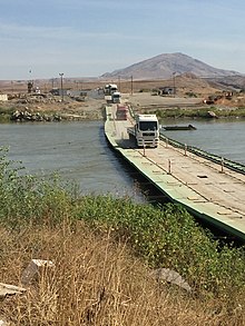
Semalka Border Crossing
Semalka Border Crossing | |
|---|---|
| Coordinates | 37°05′22″N 42°21′00″E / 37.089323°N 42.349890°E |
| Carries | Pedestrians, vehicles, containers |
| Locale | |
| Official name | Semalka Border Crossing |
| Maintained by | |
| Website | semalka |
| Location | |
 | |
Semalka Border Crossing (Arabic: معبر سيمالكا الحدودي; Kurdish: Deriyê Sêmalka), is a border crossing established between the Kurdistan Regional Government in Iraq and the Kurdish-led Autonomous Administration of North and East Syria during the Syrian Civil War about 1 km downstream from the Iraqi–Syrian–Turkish tripoint and just north of Faysh Khabur in Iraq and Khanik in Syria consisting of a pontoon bridge across the Tigris.

The border crossing has been intermittently closed by the Kurdistan Regional Government (KRG), but has been open permanently since June 2016,[1][2] and economic exchange has since then begun to normalize between Northeastern Syria and the Kurdistan Region.[1]
See also[edit]
References[edit]
- ^ a b "US welcomes opening of border between Rojava and Iraqi Kurdistan". ARA News. 2016-06-10. Archived from the original on June 10, 2016. Retrieved 2016-06-10.
- ^ "Business booming in Rojava after outlet opened with Kurdistan Region". Kurdistan24. 22 April 2017.
