
Cerro Bravo
| Cerro Bravo | |
|---|---|
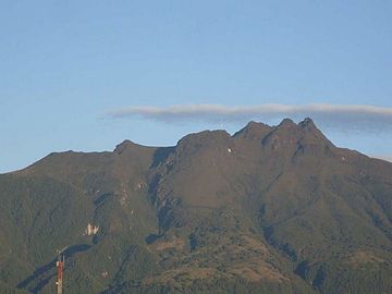
 Cerro Bravo in June 2010 | |
| Highest point | |
| Elevation | 4000+ metres (13,123+ ft)[1] |
| Listing | Volcanoes of Colombia |
| Coordinates | 5°05′31″N 75°18′00″W / 5.092°N 75.30°W[1] |
| Geography | |
 Cerro Bravo Location of Cerro Bravo in Colombia | |
| Location | Tolima |
| Parent range | Central Ranges Andes |
| Geology | |
| Age of rock | Holocene |
| Mountain type | Andesitic stratovolcano |
| Last eruption | 1720 ± 150 years |
Cerro Bravo is a stratovolcano located in Tolima, Colombia, north of the Nevado del Ruiz volcano. The rock type of the volcano is andesite.[2]
Eruptive history[edit]
As with many volcanoes in the region, Bravo's eruptions are often characterized by a central vent (caldera) eruption, followed by an explosive eruption and pyroclastic flows. However, it is unique in the fact that its eruption have also produced lava domes in its caldera. Such eruptions occurred in 1720 ± 150 years, 1050 ± 75 years, and 750 AD ± 150 years (through radiocarbon dating). Eruptions consisting of just a central vent eruption and subsequent explosive eruption took place in 1330 ± 75 years, 1310 BC ± 150 years, 1050 BC ± 200 years and 4280 BC ± 150 years.[1]
Gallery[edit]
-
 2009
2009 -
 2009
2009 -
 2014
2014


See also[edit]
References[edit]
- ^ a b c "Cerro Bravo". Global Volcanism Program. Smithsonian Institution. Retrieved 2011-08-12.
- ^ Plancha 206, 1998
Bibliography[edit]
- González, Humberto (2001). Geología de las planchas 206 Manizales y 225 Nevado del Ruiz - 1:100,000 - Memoria explicativa (PDF) (Report). INGEOMINAS. pp. 1–93. Retrieved 2017-06-09.[dead link]
- Mosquera, Darío; Martín, Pedro; Vesga, Carlos; González, Humberto (2009). Plancha 206 - Manizales - 1:100,000 (Map). INGEOMINAS. p. 1. Retrieved 2017-06-06.
Treasures of Colombia | |||||||||||||||||||||||||||||
|---|---|---|---|---|---|---|---|---|---|---|---|---|---|---|---|---|---|---|---|---|---|---|---|---|---|---|---|---|---|
| |||||||||||||||||||||||||||||
| |||||||||||||||||||||||||||||
| |||||||||||||||||||||||||||||
| |||||||||||||||||||||||||||||
Source: Wills, Fernando; et al. (2001). Nuestro patrimonio – 100 tesoros de Colombia [Our heritage – 100 treasures of Colombia] (in Spanish). El Tiempo. pp. 1–311. ISBN 958-8089-16-6. | |||||||||||||||||||||||||||||
| Western Ranges | | |
|---|---|---|
| Central Ranges | ||
| Eastern Ranges | ||
| Other | ||
| Source | ||
| Authority control databases: Geographic |
|---|
This Colombian location article is a stub. You can help Wikipedia by expanding it. |