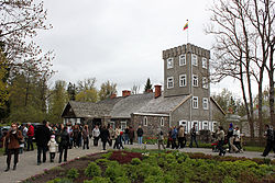
Burbiškis Manor (Radviliškis)
| Burbiškis Manor | |
|---|---|
 Burbiškis Manor | |
 | |
| General information | |
| Type | Residential manor |
| Location | Radviliškis |
| Country | Lithuania |
You can help expand this article with text translated from the corresponding article in Lithuanian. (December 2013) Click [show] for important translation instructions.
|
Burbiškis Manor is a former residential manor in Radviliškis district.[1] It is most famous for its tulips festival in spring.[2]
History[edit]
The manor was first mentioned in 1618. The first owners, the Burba family, gave the village its name.[3] From 1819 to 1941, the manor belonged to the Bażeński family. Michał Ignacy Bażeński's son Michał was married to Marija, poet and daughter of cultural activist Petras Vileišis. Kornel Makuszyński, a renowned Polish writer of children's and youth literature, was married to Emilia Bażeńska, daughter of Michał Ignacy. The couple lived in Burbiškis in 1912–14.[4] Therefore, in the early 20th century, Burbiškis was one of the places for cultural meetings of intelligentsia.
Architecture[edit]
The manor is quite well preserved with some original interior. The manor houses a small museum and a guesthouse. The buildings are surrounded by a 28-hectare (69-acre) park with man-made lakes that feature 15 islands connected by 12 bridges.[5] The park also has monuments to Romantic poet Adam Mickiewicz (erected in 1911), medieval ruler Vytautas the Great (1912), Saint Mary.[3] Every spring the park hosts a festival showcasing some 400 different varieties of tulips.[3]
References[edit]
- ^ Burbiškio dvaro istorijos ekspozicija (in Lithuanian)
- ^ Burbiškio dvare pražydo 180 tūkst. tulpių (in Lithuanian)
- ^ a b c Kelionių vadovas po Lietuvą: 1000 lankytinų vietovių norintiems geriau pažinti gimtąjį kraštą (in Lithuanian) (4th ed.). Vilnius. 2006. p. 243.
{{cite book}}: CS1 maint: location missing publisher (link) - ^ "Dwory na Litwie" (in Polish).
- ^ "Exposition on History of the Burbiškis Manor".
External links[edit]
![]() Media related to Burbiškis Manor (Radviliškis) at Wikimedia Commons
Media related to Burbiškis Manor (Radviliškis) at Wikimedia Commons
