
Aizkraukle
Aizkraukle | |
|---|---|
Town | |
 | |
 Flag  Coat of arms | |
 Aizkraukle Location in Latvia | |
| Coordinates: 56°36′15″N 25°15′14″E / 56.60417°N 25.25389°E | |
| Country | |
| Municipality | Aizkraukle Municipality |
| Town rights | 1967 |
| Area | |
| • Total | 12.93 km2 (4.99 sq mi) |
| • Land | 8.04 km2 (3.10 sq mi) |
| • Water | 4.89 km2 (1.89 sq mi) |
| Population (2023)[2] | |
| • Total | 6,947 |
| • Density | 540/km2 (1,400/sq mi) |
| Time zone | UTC+2 (EET) |
| • Summer (DST) | UTC+3 (EEST) |
| Postal code | LV-510(1-3) |
| Calling code | +371 651 |
| Website | www |
Aizkraukle (German: Ascheraden) is a town[3] in the Vidzeme region in Latvia, which is the administrative centre of Aizkraukle Municipality on the right bank of the Daugava River. The population in 2020 was at 7,018.[4]
History[edit]
In the second half of the 14th century, the Livonian Order built the Aizkraukle Castle, a few kilometres downstream from the ancient hillfort of Livs. The ruins of the castle still remain today. Before World War I, the settlement that stood near the site of modern-day Aizkraukle was known by its German name of Ascheraden.
The modern town was established in 1961 as a settlement to house the builders of the nearby hydroelectric power plant of Pļaviņas.[5] It was originally called Stučka[6] (or "Стучка", Stuchka[7] and "имени Петра Стучки", imeni Petra Stuchki[5] in Russian), for Pēteris Stučka, a Latvian communist.[5] Town status was granted to it in 1967,[5][6] which is also when it became the administrative center of Stučkas District.[citation needed] In 1990, it was renamed as Aizkraukle, after the nearest railway station.[5] The name literally means "beyond the Kraukle River."[5]
Economy[edit]
General industries in the area include power generation, woodworking, printing, and agriculture.
In 2004, Aizkraukle was awarded "The tidiest town in Latvia 2004" in its size group.
-
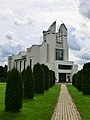 Aizkraukle Saint Thérèse of the Child Jesus Roman Catholic Church
 -
 Soviet-era supermarket
.jpg)

Notable people[edit]
- Aigars Apinis (born 1973), athlete
- Ivars Deinis (born 1977), luger
- Laura Igaune (born 1988), athlete
- Kristers Gudļevskis (born 1992), ice hockey player
- Elvis Stuglis (born 1993), footballer
- Ingars Stuglis (born 1996), footballer
See also[edit]
Citations and references[edit]
- ^ "Reģionu, novadu, pilsētu un pagastu kopējā un sauszemes platība gada sākumā". Central Statistical Bureau of Latvia. Retrieved 18 January 2023.
- ^ "Iedzīvotāju skaits pēc tautības reģionos, pilsētās, novados, pagastos, apkaimēs un blīvi apdzīvotās teritorijās gada sākumā (pēc administratīvi teritoriālās reformas 2021. gadā) 2021 - 2022". Central Statistical Bureau of Latvia. Retrieved 2 October 2023.
- ^ "Administratīvo teritoriju un apdzīvoto vietu likums". Archived from the original on 2020-08-18.
- ^ "ISG020. Population number and its change by statistical region, city, town, 21 development centres and county". Central Statistical Bureau of Latvia. 2020-01-01. Retrieved 2021-02-12.
- ^ a b c d e f Pospelov, p. 24
- ^ a b Latvijas PSR Administratīvi Teritoriālais Iedalījums, p. 47
- ^ Latvijas PSR Administratīvi Teritoriālais Iedalījums, p. 118
Cited sources[edit]
- Е. М. Поспелов (Ye. M. Pospelov). "Имена городов: вчера и сегодня (1917–1992). Топонимический словарь." City Names: Yesterday and Today (1917–1992). Toponymic Dictionary." Москва, "Русские словари", 1993.
- Latvijas PSR Augstakās Padomes Prezidija Padomju Darba Jautājumu Daļa. Latvijas PSR Administratīvi Teritoriālais Iedalījums. 1978. gads. Izdevnieciba "Liesma", Riga 1978.
| International | |
|---|---|
| National | |