Portal:New England
The New England Portal New England is a region comprising six states in the Northeastern United States: Connecticut, Maine, Massachusetts, New Hampshire, Rhode Island, and Vermont. It is bordered by the state of New York to the west and by the Canadian provinces of New Brunswick to the northeast and Quebec to the north. The Gulf of Maine and Atlantic Ocean are to the east and southeast, and Long Island Sound is to the southwest. Boston is New England's largest city and the capital of Massachusetts. Greater Boston is the largest metropolitan area, with nearly a third of New England's population; this area includes Worcester, Massachusetts, the second-largest city in New England, Manchester, New Hampshire, the largest city in New Hampshire, and Providence, Rhode Island, the capital of and largest city in Rhode Island. In 1620, the Pilgrims established Plymouth Colony, the second successful settlement in British America after the Jamestown Settlement in Virginia, founded in 1607. Ten years later, Puritans established Massachusetts Bay Colony north of Plymouth Colony. Over the next 126 years, people in the region fought in four French and Indian Wars until the English colonists and their Iroquois allies defeated the French and their Algonquian allies. (Full article...) Selected article
Plymouth Colony was an English colonial venture in North America from 1620 to 1691. The first settlement was at New Plymouth, a location previously surveyed and named by Captain John Smith. The settlement, which served as the capital of the colony, is today the modern town of Plymouth, Massachusetts. At its height, Plymouth Colony occupied most of the southeastern portion of the modern state of Massachusetts. Founded by a group including separatists who later came to be known as the Pilgrims, Plymouth Colony was, along with Jamestown, Virginia, one of the earliest colonies to be founded by the English in North America and the first sizable permanent English settlement in the New England region. Aided by Squanto, a Native American, the colony was able to establish a treaty with Chief Massasoit which helped to ensure the colony's success. The colony played a central role in King Philip's War, one of the earliest and bloodiest of the Indian Wars. Ultimately, the colony was annexed by the Massachusetts Bay Colony in 1691. Many of the people and events surrounding Plymouth Colony have become part of American mythology, including the North American tradition known as Thanksgiving and the monument known as Plymouth Rock. (Full article...)
Selected biography
Samantha Reed Smith was an American schoolgirl, peace activist and child actress from Manchester, Maine, who became famous in the Cold War-era United States and Soviet Union. In 1982, Smith wrote a letter to the newly appointed CPSU General Secretary Yuri Andropov, and received a personal reply which included a personal invitation to visit the Soviet Union, which she accepted.
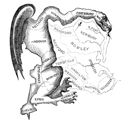
Smith attracted extensive media attention in both countries as a "Goodwill Ambassador", and became known as "America's Youngest Ambassador" participating in peacemaking activities in Japan. She wrote a book about her visit to the Soviet Union and co-starred in the television series Lime Street, before her death at the age of 13 in the Bar Harbor Airlines Flight 1808 plane crash. (Full article...) Selected picture1812 political cartoon that led to the term Gerrymandering; originally appearing in the Boston Centinel
General images -The following are images from various New England-related articles on Wikipedia.
Did you know (auto-generated)
Related portalsMore did you know...
Selected State
Rhode Island
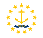
Incorporated 1776 Co-ordinates 41.7°N 71.5°W Rhode Island, officially the State of Rhode Island and Providence Plantations, is the smallest in area, the 8th least populous, but the 2nd most densely populated of the 50 U.S. states. Rhode Island was the first of the original Thirteen Colonies to declare independence from British rule, declaring itself independent on May 4, 1776, two months before any other colony. The State was also the last of the thirteen original colonies to ratify the United States Constitution. Rhode Island's official nickname is "The Ocean State," a reference to the State's geography, since Rhode Island has several large bays and inlets that amount to about fourteen (14) percent of its total area. Its land area is 1,045 square miles (2706 km2), but its total area is significantly larger. (Full article...) WikiProjectsAssociated WikimediaThe following Wikimedia Foundation sister projects provide more on this subject:
Discover Wikipedia using portals |


