
File:Tulum - 01.jpg

Size of this preview: 800 × 600 pixels. Other resolutions: 320 × 240 pixels | 640 × 480 pixels | 1,024 × 768 pixels | 1,280 × 960 pixels | 2,560 × 1,920 pixels | 3,000 × 2,250 pixels.
Original file (3,000 × 2,250 pixels, file size: 5.34 MB, MIME type: image/jpeg)
| This is a file from the Wikimedia Commons. Information from its description page there is shown below. Commons is a freely licensed media file repository. You can help. |
Summary
| Camera location | | View this and other nearby images on: OpenStreetMap |
|---|
| Description |
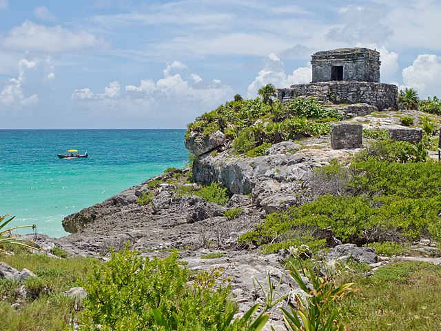
Español: Templo del Dios Viento, Tulum, Quintana Roo, México. English: Temple of the God Wind, Tulum, Quintana Roo, Mexico. Français : Le temple du dieu du Vent sur le site maya de Tulum (État mexicain du Quintana Roo).
|
||
| Date | |||
| Source | Own work | ||
| Author | Carlos Delgado |
|
Licensing

|
This picture is not in the public domain
Do not copy this image illegally by ignoring the terms of the license below, as it is not in the public domain.
If you would like special permission to use, license, or purchase the image please contact me |
I, the copyright holder of this work, hereby publish it under the following license:
This file is licensed under the Creative Commons Attribution-Share Alike 3.0 Unported license.
Attribution: Carlos Delgado
- You are free:
- to share – to copy, distribute and transmit the work
- to remix – to adapt the work
- Under the following conditions:
- attribution – You must give appropriate credit, provide a link to the license, and indicate if changes were made. You may do so in any reasonable manner, but not in any way that suggests the licensor endorses you or your use.
- share alike – If you remix, transform, or build upon the material, you must distribute your contributions under the same or compatible license as the original.

|
This image was uploaded as part of Wiki Loves Monuments 2012.
|
 |
This image has been assessed using the Quality image guidelines and is considered a Quality image.
|
This image was selected as picture of the day on Wikimedia Commons for 27 January 2013. It was captioned as follows: English: The Temple of God Wind in the Mayan Ruins of Tulum, Quintana Roo, Mexico. Other languages:
Deutsch: Der „Tempel des Windes“ der Maya im archäologischen Fundplatz Tulum im mexikanischen Bundesstaat Quintana Roo English: The Temple of God Wind in the Mayan Ruins of Tulum, Quintana Roo, Mexico. Español: Templo del Dios Viento en las ruinas mayas de Tulum, en Quintana Roo, México. Français : Temple du Dieu du Vent des ruines mayas à Tulum, Quintana Roo, Mexique. Italiano: Il tempio del dio del vento nel complesso archeologico Maya di Tulum, Quintana Roo, Messico. |
File history
Click on a date/time to view the file as it appeared at that time.
| Date/Time | Thumbnail | Dimensions | User | Comment | |
|---|---|---|---|---|---|
| current | 18:30, 17 September 2012 | | 3,000 × 2,250 (5.34 MB) | Kadellar | User created page with UploadWizard |
File usage
The following pages on the English Wikipedia use this file (pages on other projects are not listed):
Global file usage
The following other wikis use this file:
- Usage on be-tarask.wikipedia.org
- Usage on bn.wikipedia.org
- Usage on ca.wikipedia.org
- Usage on crh.wikipedia.org
- Usage on cv.wikipedia.org
- Usage on eo.wikipedia.org
- Usage on es.wikipedia.org
- Usage on es.wikivoyage.org
- Usage on fa.wikipedia.org
- Usage on fr.wikipedia.org
- Usage on hu.wikipedia.org
- Usage on ka.wikipedia.org
- Usage on ko.wikipedia.org
- Usage on krc.wikipedia.org
- Usage on la.wikipedia.org
- Usage on lbe.wikipedia.org
- Usage on os.wikipedia.org
- Usage on pl.wikipedia.org
- Usage on pt.wikipedia.org
- Usage on ru.wikipedia.org
- Usage on ru.wikinews.org
- Usage on sah.wikipedia.org
- Usage on sq.wikipedia.org
- Usage on su.wikipedia.org
- Usage on uk.wikipedia.org
- Usage on vi.wikipedia.org
- Usage on xal.wikipedia.org
- Usage on zh.wikipedia.org