
File:Suhongtu site - Sinornithomimus quarry.png

Size of this preview: 800 × 529 pixels. Other resolutions: 320 × 211 pixels | 640 × 423 pixels | 1,147 × 758 pixels.
Original file (1,147 × 758 pixels, file size: 496 KB, MIME type: image/png)
| This is a file from the Wikimedia Commons. Information from its description page there is shown below. Commons is a freely licensed media file repository. You can help. |
Summary
| Description |
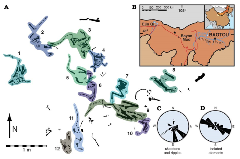
English: Suhongtu site, partial quarry map, locality map, and orientation data. A. Map of the central and northern portions of site showing the position of 12 of 13 skeletons. Skeletons 3 and 4 enlarged in Fig. 3. B. Fossil locality (41°17’ 10”N, 103°52’38”E) located 90 km northwest of Bayan Mod, InnerMongolia, China. C. Rose−diagram showing trends for skeletons (black, numbers denote skeleton count) and ripples (white). D. Mirror rose−diagram of elongated, isolated elements (n=13). Trends of skeletons have a strong, non−random (p<0.002) alignment to southeast. Flow direction of ripples is roughly perpendicular to that of elongate elements. |
| Date | |
| Source | (2008). "Mud-Trapped Herd Captures Evidence of Distinctive Dinosaur Sociality". Acta Palaeontologica Polonica 53 (4): 567–578. DOI:10.4202/app.2008.0402. ISSN 0567-7920. |
| Author | David J. Varricchio, Paul C. Sereno, Zhao Xi-jin, Tan Lin Jeffrey A. Wilson & Gabrielle H. Lyon |
Licensing
This file is licensed under the Creative Commons Attribution 4.0 International license.
- You are free:
- to share – to copy, distribute and transmit the work
- to remix – to adapt the work
- Under the following conditions:
- attribution – You must give appropriate credit, provide a link to the license, and indicate if changes were made. You may do so in any reasonable manner, but not in any way that suggests the licensor endorses you or your use.
File history
Click on a date/time to view the file as it appeared at that time.
| Date/Time | Thumbnail | Dimensions | User | Comment | |
|---|---|---|---|---|---|
| current | 05:28, 21 August 2020 | | 1,147 × 758 (496 KB) | PaleoNeolitic | {{Information |description ={{en|1=Suhongtu site, partial quarry map, locality map, and orientation data. '''A'''. Map of the central and northern portions of site showing the position of 12 of 13 skeletons. Skeletons 3 and 4 enlarged in Fig. 3. '''B'''. Fossil locality (41°17’ 10”N, 103°52’38”E) located 90 km northwest of Bayan Mod, InnerMongolia, China. '''C'''. Rose−diagram showing trends for skeletons (black, numbers denote skeleton count) and ripples (white). '''D'''. Mirror rose−diagr... |
File usage
The following pages on the English Wikipedia use this file (pages on other projects are not listed):
Global file usage
The following other wikis use this file:
- Usage on ar.wikipedia.org
- Usage on ca.wikipedia.org
- Usage on cs.wikipedia.org
- Usage on he.wikipedia.org
- Usage on hu.wikipedia.org
- Usage on sv.wikipedia.org
- Usage on www.wikidata.org
- Usage on zh.wikipedia.org