
File:PIA25912-MarsCuriosityRover-MarkerBandValley-20230408.png

Original file (3,840 × 2,160 pixels, file size: 9 MB, MIME type: image/png)
| This is a file from the Wikimedia Commons. Information from its description page there is shown below. Commons is a freely licensed media file repository. You can help. |
Summary
| Description |
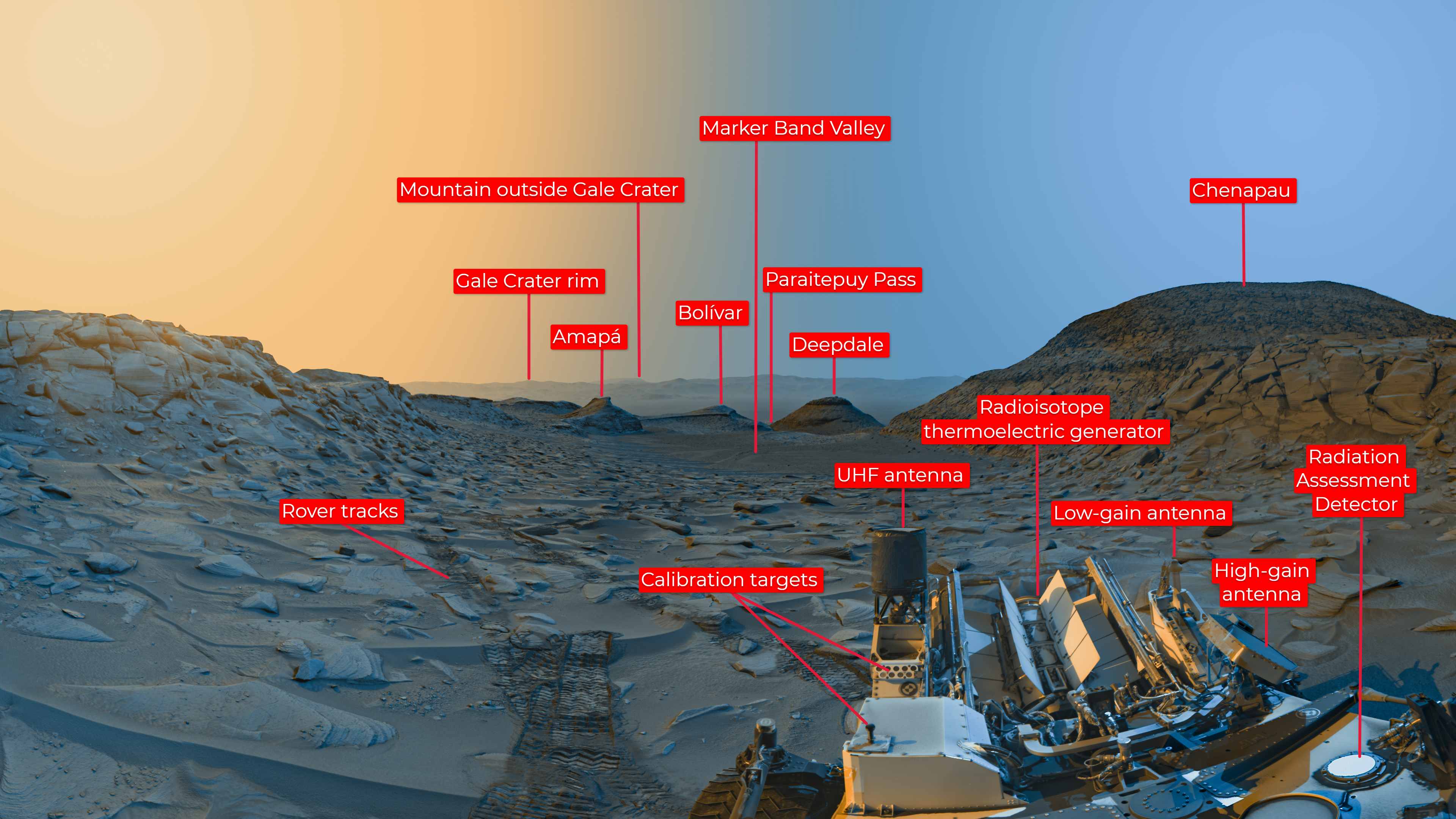
English: PIA25912: Curiosity's 'Postcard' of 'Marker Band Valley'
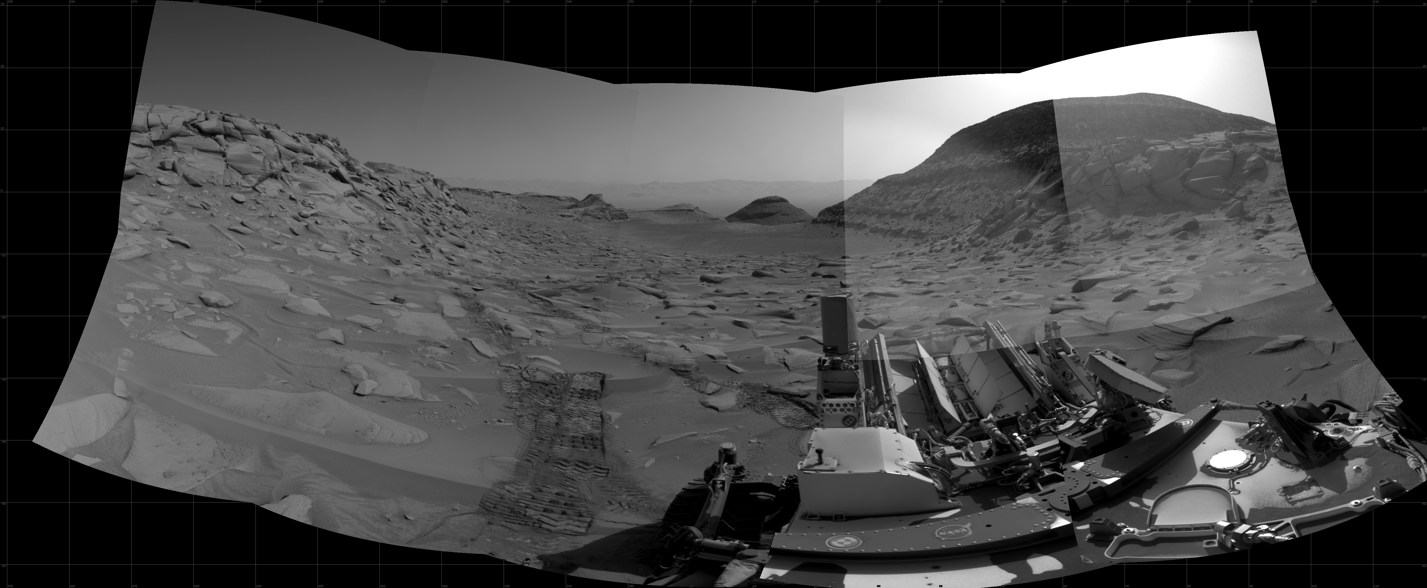
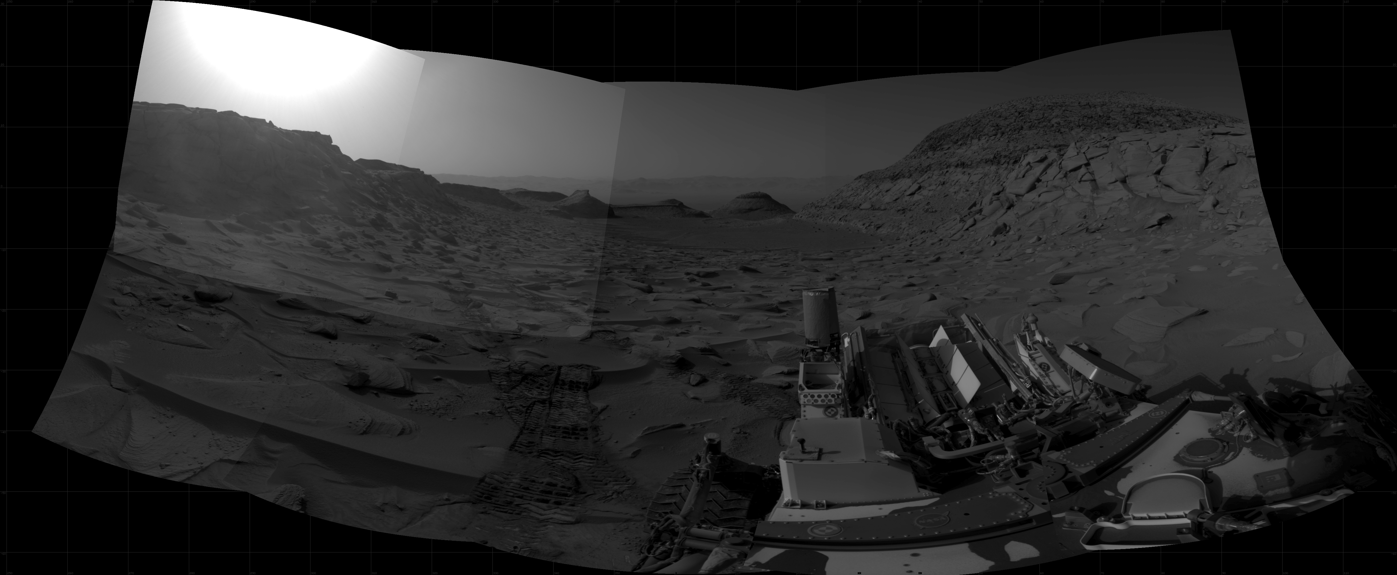
https://photojournal.jpl.nasa.gov/catalog/PIA25912  Figure A Figure B Figure C Click on images for larger versions NASA's Curiosity Mars rover used its black-and-white navigation cameras to capture panoramas at two times of day on April 8, 2023. The panoramas were captured at 9:20 a.m. and 3:40 p.m. local Mars time, then merged together. Color was added for an artistic interpretation of the scene, with blue representing the morning panorama and yellow representing the afternoon one. The resulting "postcard" is similar to one created with rover images taken in November 2021. Figure A is an annotated version of the postcard noting geographic features and elements of the rover. Figure B is the morning panorama without added color; Figure C is the afternoon panorama without added color. Each of these new panoramas took about 7 1/2 minutes to capture and include five individual images that were stitched together after being sent to Earth. By capturing the panoramas at two different times of day, the scene shows dramatic shadows similar to stage lighting coming in from the left and right of center stage. Additionally, it was winter at Curiosity's location at the time these images were captured; shadows are sharper and deeper during winter, when dust is at its lowest in the Martian atmosphere. At the bottom right of the postcard is Curiosity. The rover's three antennas and nuclear power source are visible. Trailing behind Curiosity are rover tracks, and beyond those are "Marker Band Valley," a winding region where the rover discovered unexpected signs of an ancient lake. Further below are two hills – "Bolivar" and "Deepdale" – that Curiosity drove between while exploring "Paraitepuy Pass." Curiosity is ascending the foothills of Mount Sharp, a 3-mile-tall (5-kilometer-tall) mountain found within Gale Crater; the crater rim is visible roughly 25 miles (40 kilometers) away. And because skies were so clear, a mountain beyond the crater rim can be seen, even though it's 54 miles (87 kilometers) outside of Gale. Curiosity was built by NASA's Jet Propulsion Laboratory, which is managed by Caltech in Pasadena, California. JPL leads the mission on behalf of NASA's Science Mission Directorate in Washington. |
| Date | |
| Source | https://photojournal.jpl.nasa.gov/figures/PIA25912_figA.png |
| Author | NASA/JPL-Caltech |
Licensing
This image or video was catalogued by Jet Propulsion Laboratory of the United States National Aeronautics and Space Administration (NASA) under Photo ID: PIA25912. This tag does not indicate the copyright status of the attached work. A normal copyright tag is still required. See Commons:Licensing. Other languages:
|
| This file is in the public domain in the United States because it was solely created by NASA. NASA copyright policy states that "NASA material is not protected by copyright unless noted". (See Template:PD-USGov, NASA copyright policy page or JPL Image Use Policy.) | ||
 |
Warnings:
|
File history
Click on a date/time to view the file as it appeared at that time.
| Date/Time | Thumbnail | Dimensions | User | Comment | |
|---|---|---|---|---|---|
| current | 14:01, 14 June 2023 | | 3,840 × 2,160 (9 MB) | Drbogdan | Uploaded a work by NASA/JPL-Caltech from https://photojournal.jpl.nasa.gov/figures/PIA25912_figA.png with UploadWizard |