
File:PIA18474-MarsCuriosityRover-GaleCrater-TopographicMap-PahrumpHills-20140911.jpg

Original file (3,300 × 2,550 pixels, file size: 2.11 MB, MIME type: image/jpeg)
| This is a file from the Wikimedia Commons. Information from its description page there is shown below. Commons is a freely licensed media file repository. You can help. |
Summary
| Description |
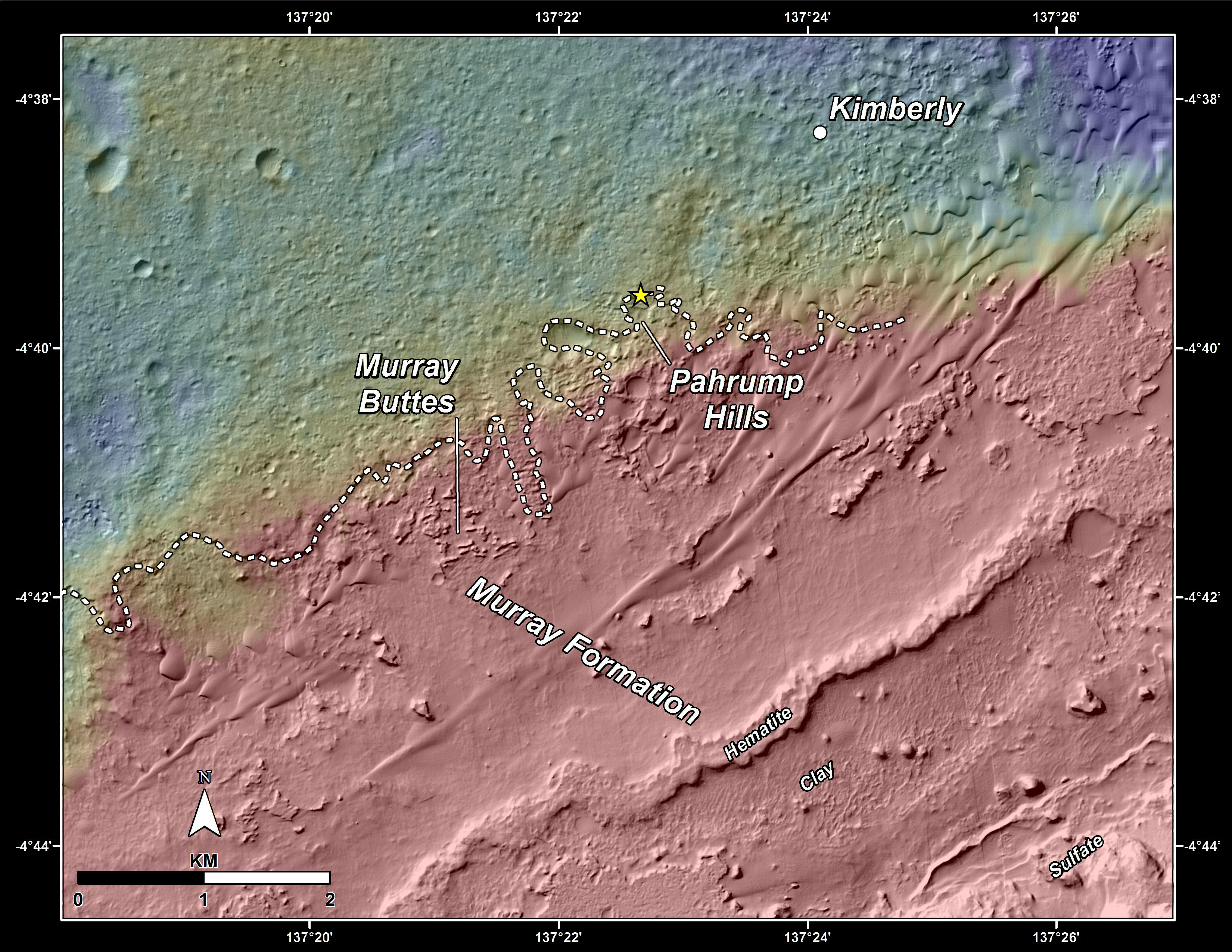
English: 09.11.2014
Slopes of Mount Sharp http://mars.jpl.nasa.gov/msl/multimedia/images/?ImageID=6573 This topography map shows a portion of the Gale Crater region on Mars, where NASA's Mars Curiosity rover landed on August 6, 2012. The rover (marked with a star) is currently headed toward "Pahrump Hills," which make up part of the "Murray Formation" of layered rocks. The white dashed line represents the contact point between rocks of Gale Crater's plains (Aeolis Palus) -- which Curiosity has investigated since landing -- and those at the base of Mt. Sharp (Aeolis Mons). By comparing the two images it can be seen that a small topographic scarp defines the contact region. In addition, the rocks of Aeolis Palus are heavily cratered whereas those of Mount Sharp have fewer craters. The maps are made using data from NASA's Mars Reconnaissance Orbiter's High Resolution Imaging Science Experiment, or HiRISE. NASA's Jet Propulsion Laboratory, a division of the California Institute of Technology, Pasadena, manages the Mars Science Laboratory Project for NASA's Science Mission Directorate, Washington. JPL designed and built the project's Curiosity rover. HiRISE is one of six instruments on the Mars Reconnaissance Orbiter. The University of Arizona, Tucson, operates HiRISE, which was built by Ball Aerospace & Technologies Corp., Boulder, Colorado. JPL manages the Mars Reconnaissance Orbiter Project for NASA's Science Mission Directorate, Washington. More information about Curiosity is online at http://www.nasa.gov/msl and http://mars.jpl.nasa.gov/msl/. |
| Date | |
| Source | http://mars.jpl.nasa.gov/msl/images/NASA-MSL-Curiosity-Rover-Gale-Crater-Topographic-Map-Pahrump-Hills-pia18474-full.jpg |
| Author | NASA/JPL-Caltech/Univ. of Arizona |
Licensing
| This file is in the public domain in the United States because it was solely created by NASA. NASA copyright policy states that "NASA material is not protected by copyright unless noted". (See Template:PD-USGov, NASA copyright policy page or JPL Image Use Policy.) | ||
 |
Warnings:
|
File history
Click on a date/time to view the file as it appeared at that time.
| Date/Time | Thumbnail | Dimensions | User | Comment | |
|---|---|---|---|---|---|
| current | 15:18, 19 September 2014 | | 3,300 × 2,550 (2.11 MB) | Drbogdan | User created page with UploadWizard |
File usage
Global file usage
The following other wikis use this file:
- Usage on tr.wikipedia.org
- Usage on uk.wikipedia.org
- Usage on zh.wikipedia.org