
File:Goodenough Island.jpeg

Size of this preview: 456 × 599 pixels. Other resolutions: 182 × 240 pixels | 365 × 480 pixels | 584 × 768 pixels | 779 × 1,024 pixels | 2,127 × 2,796 pixels.
Original file (2,127 × 2,796 pixels, file size: 733 KB, MIME type: image/jpeg)
| This is a file from the Wikimedia Commons. Information from its description page there is shown below. Commons is a freely licensed media file repository. You can help. |
Summary
| Description |
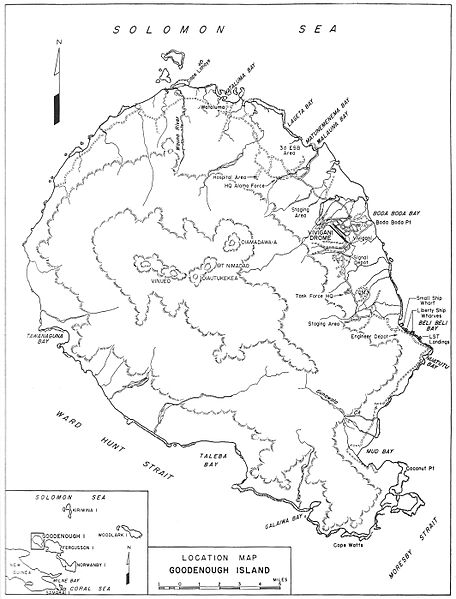
English: Map of Goodenough Island, showing location of wartime base development |
| Date | |
| Source | Airfield and Base Development (1951), p. 141. N.B. This is a US government work, written by staff of the Office of the Chief Engineer, U.S. Army, and published by the U.S. Government Printing Office. [1] |
| Author | Casey, Hugh J., ed. |
Licensing
This file is a work of a U.S. Army soldier or employee, taken or made as part of that person's official duties. As a work of the U.S. federal government, it is in the public domain in the United States.
|
 |
File history
Click on a date/time to view the file as it appeared at that time.
| Date/Time | Thumbnail | Dimensions | User | Comment | |
|---|---|---|---|---|---|
| current | 16:45, 10 March 2012 | | 2,127 × 2,796 (733 KB) | Hohum | Straightened, cropped, cleanup |
| 21:09, 5 March 2012 |  | 2,202 × 2,985 (783 KB) | Hawkeye7 |
File usage
The following pages on the English Wikipedia use this file (pages on other projects are not listed):
Global file usage
The following other wikis use this file:
- Usage on de.wikipedia.org
- Usage on fi.wikipedia.org
- Usage on fr.wikipedia.org
- Usage on it.wikipedia.org
- Usage on uk.wikipedia.org