
File:Da-ming-hun-yi-tu.jpg

Size of this preview: 683 × 600 pixels. Other resolutions: 273 × 240 pixels | 547 × 480 pixels | 895 × 786 pixels.
Original file (895 × 786 pixels, file size: 493 KB, MIME type: image/jpeg)
| This is a file from the Wikimedia Commons. Information from its description page there is shown below. Commons is a freely licensed media file repository. You can help. |
Summary
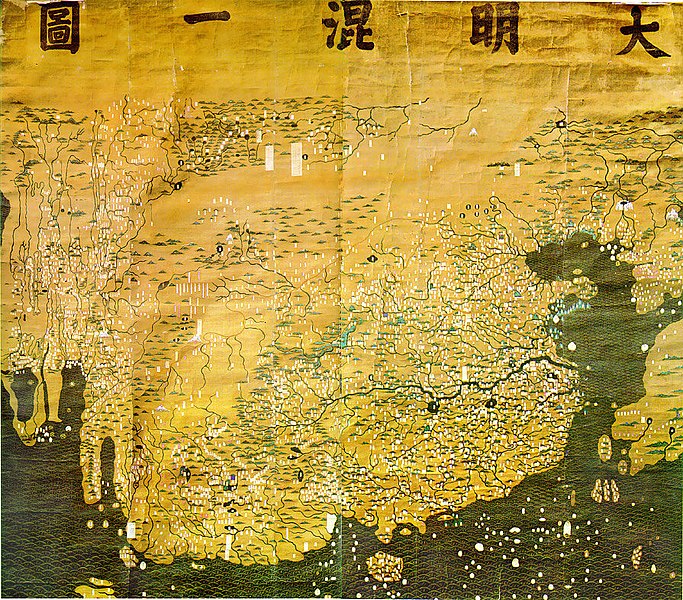
| Description | The Composite Map of the Ming Empire (Da Ming Hunyi Tu) reflects the political situation in AD 1389 but was likely painted much later. Original Chinese labels were later covered with Manchu on paper slips. |
| Date | after 1389 |
| Source | http://geog.hkbu.edu.hk/GEOG1150/Chinese/Catalog/am31_map1.htm |
| Author | Chinese (image enhanced by contributor) |
Licensing
|
This is a faithful photographic reproduction of a two-dimensional, public domain work of art. The work of art itself is in the public domain for the following reason:
The official position taken by the Wikimedia Foundation is that "faithful reproductions of two-dimensional public domain works of art are public domain".
This photographic reproduction is therefore also considered to be in the public domain in the United States. In other jurisdictions, re-use of this content may be restricted; see Reuse of PD-Art photographs for details. | ||||
File history
Click on a date/time to view the file as it appeared at that time.
| Date/Time | Thumbnail | Dimensions | User | Comment | |
|---|---|---|---|---|---|
| current | 01:14, 17 March 2008 | | 895 × 786 (493 KB) | David Trochos | {{Information |Description=The Da Ming Hun Yi Tu (Great Ming Dynasty Amalagamated Map), painted on silk in AD 1389 but with Manchu language captions superimposed on paper slips several centuries later, is the oldest surviving Chinese world map. |Source= h |
| 22:54, 16 March 2008 |  | 895 × 786 (487 KB) | David Trochos | {{Information |Description=The Da Ming Hun Yi Tu (Great Ming Dynasty Amalagamated Map), painted on silk in AD 1389 but with Manchu language captions superimposed on paper slips several centuries later, is the oldest surviving Chinese world map. |Source= h |
File usage
The following pages on the English Wikipedia use this file (pages on other projects are not listed):
Global file usage
The following other wikis use this file:
- Usage on bn.wikipedia.org
- Usage on de.wikipedia.org
- Usage on es.wikipedia.org
- Usage on fa.wikipedia.org
- Usage on fa.wikibooks.org
- Usage on fr.wikipedia.org
- Usage on hr.wikipedia.org
- Usage on id.wikipedia.org
- Usage on it.wikipedia.org
- Usage on ja.wikipedia.org
- Usage on ko.wikipedia.org
- Usage on sl.wikipedia.org
- Usage on ur.wikipedia.org
- Usage on www.wikidata.org
- Usage on zh.wikipedia.org