
File:Combined map - British and Mongol Empires.svg

Size of this PNG preview of this SVG file: 800 × 406 pixels. Other resolutions: 320 × 162 pixels | 640 × 324 pixels | 1,024 × 519 pixels | 1,280 × 649 pixels | 2,560 × 1,298 pixels | 939 × 476 pixels.
Original file (SVG file, nominally 939 × 476 pixels, file size: 1.12 MB)
| This is a file from the Wikimedia Commons. Information from its description page there is shown below. Commons is a freely licensed media file repository. You can help. |
Summary
| Description |
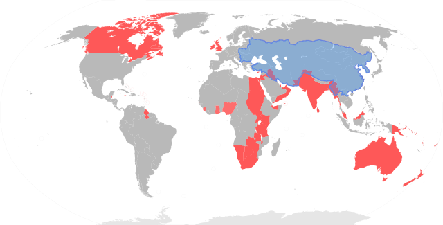
English: Combined map - British and Mongol Empires |
| Date | |
| Source | Own work |
| Author | Amitchell125 |
Licensing
I, the copyright holder of this work, hereby publish it under the following license:
This file is licensed under the Creative Commons Attribution-Share Alike 4.0 International license.
- You are free:
- to share – to copy, distribute and transmit the work
- to remix – to adapt the work
- Under the following conditions:
- attribution – You must give appropriate credit, provide a link to the license, and indicate if changes were made. You may do so in any reasonable manner, but not in any way that suggests the licensor endorses you or your use.
- share alike – If you remix, transform, or build upon the material, you must distribute your contributions under the same or compatible license as the original.
File history
Click on a date/time to view the file as it appeared at that time.
| Date/Time | Thumbnail | Dimensions | User | Comment | |
|---|---|---|---|---|---|
| current | 12:07, 19 November 2020 | | 939 × 476 (1.12 MB) | Amitchell125 | corrections |
| 15:57, 18 November 2020 |  | 939 × 476 (952 KB) | Amitchell125 | removed transparency | |
| 15:55, 18 November 2020 |  | 939 × 476 (952 KB) | Amitchell125 | Uploaded own work with UploadWizard |
File usage
The following pages on the English Wikipedia use this file (pages on other projects are not listed):
Global file usage
The following other wikis use this file:
- Usage on fi.wikipedia.org
- Usage on ko.wikipedia.org
- Usage on sr.wikipedia.org