
File:Acraman Impact Structure, South Australia.jpg

Size of this preview: 600 × 600 pixels. Other resolutions: 240 × 240 pixels | 480 × 480 pixels | 768 × 768 pixels | 1,024 × 1,024 pixels | 2,048 × 2,048 pixels | 2,668 × 2,668 pixels.
Original file (2,668 × 2,668 pixels, file size: 3.31 MB, MIME type: image/jpeg)
| This is a file from the Wikimedia Commons. Information from its description page there is shown below. Commons is a freely licensed media file repository. You can help. |
Summary
| Description | |
| Date | |
| Source | NASA Earth Observatory |
| Author | Jesse Allen |
Image captured by the Moderate Resolution Imaging Spectroradiometer (MODIS) on NASA’s Terra satellite. Data obtained from the Goddard Level 1 and Atmospheric Archive and Distribution System (LAADS).
Licensing
| This file is in the public domain in the United States because it was solely created by NASA. NASA copyright policy states that "NASA material is not protected by copyright unless noted". (See Template:PD-USGov, NASA copyright policy page or JPL Image Use Policy.) | ||
 |
Warnings:
|
| Annotations | This image is annotated: View the annotations at Commons |
File history
Click on a date/time to view the file as it appeared at that time.
| Date/Time | Thumbnail | Dimensions | User | Comment | |
|---|---|---|---|---|---|
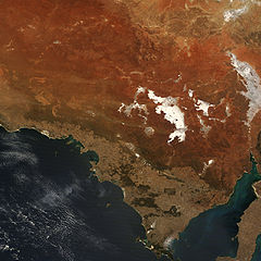
| current | 11:37, 1 March 2010 | | 2,668 × 2,668 (3.31 MB) | Originalwana | {{Information |Description={{en|1=Orange and brown soils mix with off-white saltpans, including Lake Gardiner and Lake Everard in this true-colour image. Dotted white lines indica |
File usage
The following pages on the English Wikipedia use this file (pages on other projects are not listed):
Global file usage
The following other wikis use this file:
- Usage on pl.wikipedia.org
- Usage on ro.wikipedia.org